skip to main |
skip to sidebar
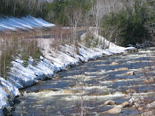
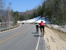
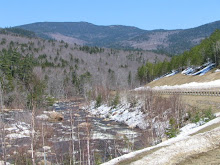
Since its Memorial Day weekend, let's do a ride that is away from the crowds and traffic. North Road is a gem!! It is a scenic, quiet road which goes from the eastern end of Gorham to Shelburne to Gilead and then to Bethel, ME. The road goes along the north side of the Androscoggin River. Route 2, which has trucks, tourists and traffic, travels along the south ride of the river. Start at the intersection of North Road and Hogan Road, on the north side of the river, ready to ride at 10:00. To get to this point, drive north over Pinkham Notch on Route 16. Turn right at the intersection with route 2 in Gorham. Drive about 3 miles, and turn left onto North Road, just after a beautiful stone house and barn. Cross the river at the dam, and proceed about 1/4 mile to where North Road bears sharply right. Hogan Road, a dirt road with access to several trailheads, comes in from the left at this point, and there is a dirt parking area there. PLEASE CARPOOL to minimize the number of cars in this lot (see below..)!The entire ride on North Road to the picnic area alongside the river in Bethel, and back, is 39 miles. The ride is not difficult, no notches! There are flat sections, sections of rolling hills, lots of scenery and occasional views of the river. Near the end, just before reaching Route 2/Route 5, there is a bike path that turns right at a red fire hydrant and goes behind the water slide park. The path goes for 1.1 miles, ending at a nice picnic spot (and porta-potty). There are many options for food in Bethel, or just bring your own.
Longer Options: After the picnic area, you can continue on Intervale Rd (quiet and scenic like North Road!!!) for another 12 miles to Rumford Corner, and yet another 12 miles to Rumford. Do it all for ~87 miles roundtrip (see maps below).Shorter Options: Since the ride is out-and-back, you can decide when you've had enough and turn back to the parking lot:To Shelburne and back is 10.2 miles round tripTo the Gilead steel trestle bridge is 18.6 miles round tripOr, to have fewer miles, but still join in on the eating and chatting at the picnic area in Bethel, drive to the Gilead bridge (Bridge Street), park there at the canoe parking area on the southwest side of the bridge, and join the riders there as they ride by on North Road at about 10:50-11:00. Starting at the bridge and riding to Bethel will give you a 20 mile round trip.CARPOOLING!To carpool, meet at the Dunkin Donuts in Glen at 8:45-9:00 if you can either take a bike or two in/on your car, or if you would like to join a carpool. Tom and I can take 4 more bikes and 3 more riders. Email me if you want to arrange for a ride or riders: marianneborowski@yahoo.com and I will try to link up cars and bikes. Carpools will leave Dunkin Donuts at 9:10.For a map you can play with, click on: For the longer option, riding to Rumford and back, see this map:
For the 60 mile ride:
9:30, ready to Ride at the Mount Cranmore parking lot, North Conway
For the 40 mile ride:
10:00, Ready to ride at the new Maine Information Center, just over the Maine State line on route 302 in Fryeburg, ME. As you travel east on route 302, it is on your right. It is a new building that looks like a railroad station. Parking and bathrooms available.
For the 20 mile ride:
10:45, ready to ride at the white church at the corner of route 113 and Fish St, North Fryeburg, ME.
All riders can meet at Rosie's, a restaurant/store in Lovell for lunch or snacks.
At the completion of the ride, pack up and meet at The Moat in North Conway on Route 16 for food, beer and friends.
Map for the 60 mile option:Map for the 40 mile option:Map for the 20 mile option:
November 2008 - Saturday November 1 The Snowville Loop, in reverse.
See the details in Ride Description
- Saturday November 8 West Side Road, Passaconaway, The Kanc
See the details in Ride Description
8:00am Saturday: RIDE CANCELLED Due to cold and showers
The crowd enjoying the beer and appetizers at The Moat tonight decided the ride for this Saturday. Since we have already Cranked Some or All of the Kanc and Crawford Notch, Pinkham Notch just could not be left out.The plan would be to ride to Gorham for lunch. Eat at The White Mountain Cafe (one of our sponsors!). I think that the timing, as listed below, will likely put us all together in Gorham at about 12:30 for lunch. As you cruise into Gorham, take an immediate left after the railroad tracks onto Railroad Ave (about 100 yards BEFORE you get to the intersection where 16 takes a left) to enter the area between the park and the railroad cars. This is a good place, off the main road, to regroup and have easy access to the cafe.
Meet at the Rocky Branch Parking lot, (on route 16, just north of the Dana Place Inn, on the left) 10:00 am, ready to ride30 miles round trip.It is not a hard climb if you take it easy and stop occasionally to view the scenery. Later in the season you will just crank right up it and feel really good about your progress. The ride back up from Gorham is a gradual climb with only a very short section, just before Wildcat, where you will work.Easier Options:Climb the notch just once option: AMC Pinkham Notch parking lot. ~11:00 am. 22 miles RTCatch the riders coming up (likely stopping to use the bathroom at the AMC!) and join in for the wonderful cruise downhill to Gorham.The ride back up is not difficult! Crawford is harder.Easiest option: Great Glen Trails parking lot ~11:15 am. 17 miles RTCatch the riders cruising downhill. The ride back up to Great Glen from Gorham is surprisingly gradual.
Here is the map to play with. You can add comments about all the rides and rate them in the MapMyRide site.