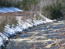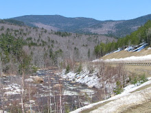
With a forecast of sunshine tomorrow, it is worth trying for one more ride. The forecast for tomorrow, Wednesday the 12th looks like the best of the week.
Anyone interested in a ride?? It could be the last, or one of the last days for an enjoyable ride without getting too cold...
Meet at the parking lot behind the Eastern Slope Inn, ready to ride at 11:00 am.
The route will be the riders choice -- either down to The Eaton Store or Purity Springs via 153 or change it a bit and do it via North South Road, Stark Road and Rt 153, or do the Passaconaway/Kanc. We can decide depending on weather and timing.
One more, anyone??
Tuesday, November 11, 2008
Sunday, November 9, 2008
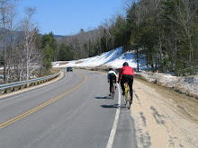
Dirt and Pavement Ride Tuesday, November 11th
I want to test an idea for some part pavement/part dirt road rides: "Mixed Surface Rides".
Is anyone interested??
Wider tires, preferably 32 mm or greater (28 mm would work if you are careful) are perfect for these rides. A mountain bike might also work, but the pavement sections could be tedious on the fat knobbies after many miles. The rides I have done lately are about 1/4 dirt road, 3/4 pavement. There are so many fun possibilities of rides using the dirt roads to link the pavement sections. Riding the dirt is good on a cold day, since the speed is lower -- less windchill!!
The ride I have in mind for Tuesday is in North Fryeburg, right near where we always ride in the corn fields and turf farms, but the dirt part takes us down the western side of the Old Saco River, to the Hemlock Covered Bridge 15 miles round trip. If we continue, we can end up at the southern end of Moose Pond in Denmark. This would be 30 miles round trip. This is an out-and-back ride, so we can go as far we like then turn back. In contrast to most of the "Mixed Surface Rides" I have done lately, this one is more dirt than pavement, so a mountain bike would be OK to try on this one.
Date: Tuesday, November 11th
Please: Send me an email if you are interested just so I know if anyone will be joining me!! marianneborowski@yahoo.com. (I have 7 riders as of Monday evening)
Meet: 11:00 am; ready to ride
Where: Parking area next to the North Fryeburg Fire Station, on the corner of Route 113 and South Chatham Road. Bring snacks and/or lunch to eat - there are lots of sunny spots along the river for a snack and a rest.
Since the weather forecast is looking good over the next few days, I will likely post some of the last rides of the season for Wednesday and Thursday!
Map:
Saturday, November 8, 2008
Ride on Sunday, November 9th
According to the forecasts, the weather should clear over tomorrow morning, with the sun coming out around mid-day. How about another try at the West Side Road-Passaconaway-Kanc ride?
Meet: 11:00 am; ready to ride
Where: Parking lot behind the Eastern Slope Inn, North Conway. Enter lot from River Road.
How far: ~28 miles. We can ride up as much of the Kanc as the weather permits!
Meet: 11:00 am; ready to ride
Where: Parking lot behind the Eastern Slope Inn, North Conway. Enter lot from River Road.
How far: ~28 miles. We can ride up as much of the Kanc as the weather permits!
Friday, November 7, 2008
Not Fun in the Fog, November 8th!
I have already heard from a few riders that do not want to go out into the fog today, so I also will not show up for the ride.
Looks like tomorrow may be better in the afternoon-- I will post a ride tonight if the weather looks good for a ride tomorrow. Monday and Tuesday look nice -- so watch for posted rides!!
Friday, October 31, 2008
Saturday November 1st
For this Saturday November 1st, mid 40's and sunshine should be good for a ride!
Let's do the Snowville Loop in reverse -- The Ellivwons Loop??
Just think!! riding DOWN Sugarapsa Hill!!
It is relatively short ride (25 miles) and should be sunny with a lot of leaves off the trees - good for a cool day in the sun. I have added Stark Road into the route- it is a nice road to ride, and is parallel to Route 153.
According to the forecast, we need to start later in the morning in order for the temperature to warm up to above 40.
Meet: Conway Village - Parking lot behind the bank and Mountain Center Physical Therapy near the corner of Routes 153 and 16
Time: Ready to ride at 11:00
Bring: Snacks to eat along the way - we will keep moving and not stop for a sit-down lunch
Clothing to keep warm -- a headband, skull cap or helmet cover to keep the head and ears warm; extra gloves or mittens, woolly thick socks or shoe covers; cross country ski clothing. With the sunshine, it is pleasantly warm while riding the bike.
We will ride to Stark Road, then turn south on Route 153 to Crystal Lake. We could stop to get a snack at the Eaton Store. Then it is a relatively easy climb to Snowville. Enjoy Asparagus Hill in the downhill direction, then head to Brownfield Road. There is some uphill there, but not hard - the downhill cruise to Center Conway is great!!
Want 14 More Miles? Leave from the parking lot behing the Eastern Slope Inn by 10:15.
Map:
Friday, October 24, 2008
Saturday Oct 25 Ride Cancelled
Looks like Saturday will be mostly cloudy and cool, with rain expected in the afternoon. Since there is no sunshine predicted, it will likely be too cold for an enjoyable ride.
Let's just wait until next Thursday and/or Saturday for a sunny end-of-season ride! Hopefully we can get another few in....
Let's just wait until next Thursday and/or Saturday for a sunny end-of-season ride! Hopefully we can get another few in....
Thursday, October 16, 2008
Saturday October 18th
Lakes and Pine Barrens Ride
Saturday looks like a sunny and cool, crisp, fall day. Great day for a bike ride in the fall foliage!
Let's do a ride south of the valley where the temperatures may be a bit warmer than the notches, and the foliage still at peak.
The Lakes and Pine Barrens Ride starts at the King Pine Ski Area parking lot (across the street from the lifts), travels south down route 153, then goes east though the Ossipee Pine Barrens on Bennet Road. The route goes by Camp Calumet at the northern tip of Ossipee Lake, crosses Route 16 and goes on Route 25 in West Ossipee for about a mile, then takes old route 25 and 113 into Tamworth Village. Go directly to The Other Store for snacks or lunch (or for more fall foliage along the riverside, ride up the Chinnook Trail to Wonalancet and back). After the lunch stop in Tamworth, return via Depot Road, the northern end of Silver Lake, East Madison Road, and up and over the hill back to King Pine.
Here is a map:
Saturday looks like a sunny and cool, crisp, fall day. Great day for a bike ride in the fall foliage!
Let's do a ride south of the valley where the temperatures may be a bit warmer than the notches, and the foliage still at peak.
The Lakes and Pine Barrens Ride starts at the King Pine Ski Area parking lot (across the street from the lifts), travels south down route 153, then goes east though the Ossipee Pine Barrens on Bennet Road. The route goes by Camp Calumet at the northern tip of Ossipee Lake, crosses Route 16 and goes on Route 25 in West Ossipee for about a mile, then takes old route 25 and 113 into Tamworth Village. Go directly to The Other Store for snacks or lunch (or for more fall foliage along the riverside, ride up the Chinnook Trail to Wonalancet and back). After the lunch stop in Tamworth, return via Depot Road, the northern end of Silver Lake, East Madison Road, and up and over the hill back to King Pine.
The distance is 34 miles.
Add more distance by starting out of Conway Village (about 24 miles extra) or doing the extra miles to Wonalancet.
Meet at the King Pine Ski Area parking lot at 10:00am ready to ride.
Bring lunch or snacks. We can eat at the picnic tables behind The Other Store (or the other store next to it...).
For those from Glen/Bartlett, meet for carpooling at the Grant's (old Dunkin Donuts location) parking lot at 9:00am.Here is a map:
Thursday, October 9, 2008
Saturday October 11th Bike for Books
BIKE for BOOKS!!
Let's get a few groups together and make this a fun weekend club ride!!
Riders can meet at 8:30 am at the registration at the John Fuller School to ride together for the 30 mile ride.
Riders who want to do an easier paced 20 mile ride can meet at 9:30 am at the John Fuller School.
Here is the info from the North Conway Library:
This Saturday will be perfect weather and peak foliage for Bike for Books- the No. Conway Library's mountain bike tour.
Sign up on Saturday morning from 8:30-10:30 at the John Fuller School or pre-register at the North Conway Library. Download your registration form at http://www.northconwaylibrary.com/ .
This day of mountain biking and pizza and ice-cream for the whole family is a fundraiser for the library- please join us and support the library.
Here is more info:
Bike for Books - A Fall Foliage Mountain Bike Tour of the Mount Washington Valley
The North Conway Public Library will hold its seventh annual Bike for Books fund raiser on Saturday, October 11th, 2008. This scenic mountain bike tour of the Mount Washington Valley during peak fall foliage season offers different route options to accommodate various ability levels from novice to expert mountain biker and for children. The tour will begin between 8:30 and 10:30 a.m. and is expected to conclude by early afternoon—every participant can choose their own route and own pace since this is a tour and not a race. The mountain bike trails will be well-marked, nobody will get lost. Food and drinks along the way will be provided to all participants.
All bikers and volunteers will receive a book, a bike bottle, and are invited to a free big lunch at the finish (Elvio’s pizza, Ben & Jerry’s ice cream, coffee from Frontside Grind, and more).
Many local businesses, restaurants, and ski areas have donated numerous free giveaways and gift certificates.
The Registration fee is $20 for individuals, $30 for couples, $35 for families, and $10 for students 17 and under. $5 off for pre-registration by October 4th —forms may be picked up at the North Conway Public Library or downloaded at http://www.northconwaylibrary.com/ . Registration on the day of the event will be held at the John Fuller School from 8:30 to 10:30 a.m.
FMI check http://www.northconwaylibrary.com/ or contact the library at (603) 356-2961.
Wednesday, October 1, 2008
Saturday October 4th: Polly's Pancakes
John Renda invites everyone for a fall foliage ride to Polly's Pancakes in Sugar Hill.
Here is the plan from John:
"Here's what I'm thinking for the route over to Polly's. It will be around (38.5 mi.) to Polly's.
Start at the Bartlett school (near the blinking light in Bartlett Village - intersection of Bear Notch Rd with Route 302) at 8:00am ready to ride. Follow Rt.302 up thru Crawford Notch with a quick stop at the Highland Center, then continue on Rt.302 up past Bretton Woods to the light in Twin Mt., keep going straight on 302 into Bethlehem to the juntion of Rt.142., I think there is a store there to get drinks. Ride up the hill on 142 then I think it is all flat and downhill into Franconia. In town turn right on Rt.18 down to the junction of Rt.117 then it's about a mile and a half climb up to Polly's. Note: We should call ahead to put our name in when we get into Franconia.
After the feast people will have the option of driving home (if you have a driver for your car) or several us will be riding back to Bartlett via the Franconia bike path into Lincoln and climbing up the Kank then down to Bear Notch Rd. and back to the school. The return trip will be around (47 mi.) for a total distance of about ( 86 mi.), and LOTS of climbing. Then we could go to the Parka for a well deserved beer."
Thursday, September 25, 2008
Saturday September 27th Rained Out
The weather forecast does not look good for Saturday -- looks like a rainout.
Let's hope for next Saturday -- lots of good riding to be done in beautiful fall foliage!!!
Let's hope for next Saturday -- lots of good riding to be done in beautiful fall foliage!!!
Wednesday, September 10, 2008
Saturday Ride 9-13 Sugar Hill
Leader: John Renda
Time: Saturday, 9-13 at 9:00 am ready to ride
Place: Franconia in small park on Academy St. (off rt116 south first street 0n left)
This 45 mile ride takes us through a beautiful section of the White Mountains. Head north on rt18 and take rt 117 to Sugar Hill. Continue all the way to rt 10/302. Follow these rts south to a left on rt112. Continue through Swiftwater and take right on French Pond road. Follow this road to rt 116 (Center Haverhill) and turn left. Stay on rt116 back to Franconia.
The plan is to meet back in Franconia and call to Polly's Pancake house for a great pancake brunch.
Car pooling alternative is to meet at the Albany covered bridge ready to leave by 8:00
Wednesday, September 3, 2008
Saturday Ride September 6th
CANCELLED DUE TO HEAVY RAIN FORECAST
Grafton Notch Loop for Saturday Sept 6th
Peter and Sally Minnich will host this ride.
Peter sends this infomation: Start at the Common in Gorham at 8:00, ride North Road to Bethel, Route 2 to Newry, Route 26 to Errol, then Route 16 back to Gorham. It's an elegant, not-too-hard loop that took us between six and seven hours at a modest pace of about 14 miles per hour. The notch climb gains about 500 vertical feet with a couple of short climbs before Upton and a couple more before the long downhill into Errol.
For a shorter option, you can ride North Road to Bethel out-and-back (~40 miles) or North Road up to the top of Evans Notch out-and-back (~40 miles).
For a map of the ride:
Tuesday, August 19, 2008
THE BYOB3!!
THE MWVVELO BICYCLE CLUB'S FREE BYOB3 RIDE AND BBQ WILL BE HELD THIS COMING SATURDAY AUGUST 23RD (RAIN DATE 24TH.)
THIS IS FREE AND OPEN TO ANYONE SO INVITE FRIENDS AND FAMILY.
PETER MINNICH AND MARIANNE BOROWSKI HAVE PLANNED RIDES FOR CYCLISTS OF ALL ABILITIES AND AMBITIONS FOR THE DETAILS..See links to maps below to view ride routes.
MAPS WILL BE AVAILABLE AT THE START FOR ALL RIDES.
BRING FOOD AND WATER AS THESE RIDES WILL NOT BE SUPPORTED WITH ANY REST STOPS.
THERE WILL BE PLACES TO STOP FOR FOOD AND DRINKS.
Shorter Rides (start at 9:00am):
ONE BANANA RIDE:
SHORT EASY 20 + MILE SOCIAL RIDE, "Passaconaway Road/Kank Falls Ride"
TWO BANANA RIDE:
A 40 MILE INTERMEDIATE MORE CHALLENGING RIDE. "Bear Notch Loop",
THESE 2 RIDES WILL HAVE MAPS, LEADERS AND SWEEPS WITH NO DROPS!!
START TIME IS 9AM FOR THESE 2 RIDES
THESE 2 RIDES WILL START AT THE PUBLIC PARKING FACILITY BEHIND THE EASTERN SLOPES INN OFF RIVER ROAD IN NORTH CONWAY.
LONGER RIDES (start at 7:00 am):
2 BUNCH OF BANANAS RIDES
START TIME IS 7AM AT ECHO LAKE STATE PARK LOT FOR THESE 2 LONG VERY CHALLENGING RIDES.
A 95 MILE 3 Notch Ride (Kanc, Franconia and Crawford) OR 110 MILES 4 Notch Ride (Kanc, Kinsman, Franconia, Crawford).
RIDERS SHOULD MEET AT 7AM AT ECHO LAKE STATE PARK LOT OFF WEST SIDE ROAD. (PARKING WILL BE AVAILABLE AT FRECHETTE OIL LOT).
BUT COME TO ECHO LAKE AND MEET THERE FIRST.
DIRECTIONS, MAPS AND LEADERS WILL BE AVAILABLE.
CAN'T MAKE THE RIDE ?
WELL STILL COME TO THE BBQ!!
THE BBQ WILL BE HELD AT ECHO LAKE ST. PARK STARTING AT 3:30PM TILL ???
LOOK FOR THE CLUB BANNER!! THE CLUB WILL PROVIDE BURGERS, DOGS, SOFT DRINKS AND MOAT BEVERAGES.
IF YOU CAN, PLEASE BRING A DESSERT OR SALAD OR SIDE DISH TO SHARE. REMEMBER TO BRING A CHAIR SO YOU CAN REST FROM YOUR RIDE!!
IF YOU WANT MORE INFO DICK POLLOCK IS THE EVENT COORDINATOR AND CAN BE CONTACTED AT 603 7708277
DICK STILL NEEDS A PROPANE GRILL THAT CAN BE USED AT THE BBQ.
PLEASE FORWARD THIS INFO TO ANY OF YOUR NON CLUB MEMBER FRIENDS WHO MIGHT LIKE TO RIDE AND JOIN US AT THE BBQ
.
AND ...PLEASE REMEMBER, THIS EVENT IS FREE AND OPEN TO ALL!!!!
Look at the routes on http://www.mapmyride.com/
Search for the rides using the keywork BYOB3, or use these direct links:
For the 23 mile ride: "Passaconaway"
For the 40 mile ride: "Bear Notch Loop"
For the 95 mile ride: "Kanc, Franconia and Crawford"
For the 110 mile ride: "Kanc, Kinsman, Franconia and Crawford"
Friday, August 15, 2008
SUNDAY RIDE August 17th
Let's ride to THE BASIN on SUNDAY August 17th
With the Sunday forecast looking PERFECT, let's go for a ride in the SUN on Sunday!
The Saturday forecast just isn't a good bet.
The Basin is a great ride!!! - It is a small glacial lake surrounded by mountains southwest of Evans Notch.
Meeting Place: Grassy park next to the North Fyreburg Fire station. This parking area is on the corner of Route 113 and South Chatham Road (near the intersection with Harbor Road). Do not park at the fire station which could block access to the firefighers.
To get there from North Conway - Drive over Hurricane Mountain Road, then at the end turn left onto Green Hill Road. Follow this north for about 5 miles. The road will intersect with Route 113 in North Fryeburg (the name of the road changes to South Chatham Road) The parking area is on your immediate right side.
When: 9:00 am ready to ride
Carpool from Glen: Meet at Dunkin Donuts at 8:15 am to carpool
The route: We will ride the sunny flats of the turf farms and potato and corn fields, then head up Union Hill Road, New Road and 113 North to The Basin for a picnic lunch.
Bring: Picnic to eat lakeside at The Basin; water, snacks. There is no place to buy food on the way.
How far: ~30 miles
Tougher option? Go up Evans Notch from the Basin. It's only a mile, but it's a steep one.
Here is a map for the ride:
Don't forget: Pump your tires, lube your chain, carry a spare tube, patch kit, tire irons and pump.
Thursday, July 31, 2008
Sunday, August 3 Sugar Hill Ride
Due to weather, this ride is cancelled. John's 2nd cancellation
Leader: John Renda
This under 40 mile ride starts in Franconia, on Main street, and heads north on Main Street. Turn left on rt 117 for a nice climb towards Sugar Hill. Continue through Sugar Hill for a long, downhill grade all the way to Route 302 and 10. Turn left and continue south through Bath and turn left on Rroute 112 (the western portion on the Kanc). Follow rt 112 to rt 116. Turn left on rt 116 through Easton and all the way back to Franconia to complete the loop.
Start time: 10:00
Where to park: in Franconia on rt 116 towards Easton in small park on right before river crossing.
For carpooling, meet at the Albany Covered brigde parking lot (the one closest to the Kanc) and be ready to leave there by 9:00.
Sunday, June 29, 2008
North Road for the Holiday Weekend, Saturday, July 5th
Since it is Fourth of July Weekend, how about a Saturday Ride that is away from the crowds and traffic?
We did North Road over the Memorial Day Weekend and it was a quiet respite from the congestion of the Valley. It is also a great ride for all your houseguests to enjoy!!
North Road is a scenic, quiet road which goes from the eastern end of Gorham to Shelburne to Gilead and then to Bethel, ME. The road goes along the north side of the Androscoggin River. Route 2, which has trucks, tourists and traffic, travels along the south ride of the river.
Start at the intersection of North Road and Hogan Road, on the north side of the river, ready to ride at 10:00. To get to this point, drive north over Pinkham Notch on Route 16. Turn right at the intersection with route 2 in Gorham. Drive about 3 miles, and turn left onto North Road, just after a beautiful stone house and barn. Cross the river at the dam, and proceed about 1/4 mile to where North Road bears sharply right. Hogan Road, a dirt road with access to several trailheads, comes in from the left at this point, and there is a dirt parking area there. PLEASE CARPOOL to minimize the number of cars in this lot (see below..)!
The entire ride on North Road to the picnic area alongside the river in Bethel, and back, is 39 miles. The ride is not difficult, no notches! There are flat sections, sections of rolling hills, lots of scenery and occasional views of the river. Near the end, just before reaching Route 2/Route 5 in Bethel, there is a bike path that turns right at a red fire hydrant and goes behind the water slide park. The path goes for 1.1 miles, ending at a nice picnic spot (and porta-potty).
There are many options for food in Bethel, or just bring your own.
Longer Options: After the picnic area, you can continue on Intervale Rd (quiet and scenic like North Road!!!) for another 12 miles to Rumford Corner, and yet another 12 miles to Rumford. Do it all for ~87 miles roundtrip (see maps below).
Shorter Options: Since the ride is out-and-back, you can decide when you've had enough and turn back to the parking lot: To Shelburne and back is 10.2 miles round trip To the Gilead steel trestle bridge is 18.6 miles round trip Or, to have fewer miles, but still join in on the eating and chatting at the picnic area in Bethel, drive to the Gilead bridge (Bridge Street), park there at the canoe parking area on the southwest side of the bridge, and join the riders there as they ride by on North Road at about 10:50-11:00. Starting at the bridge and riding to Bethel will give you a 20 mile round trip.
CARPOOLING! To carpool, meet at the Dunkin Donuts in Glen at 8:45-9:00 if you can either take a bike or two in/on your car, or if you would like to join a carpool. Carpools will leave Dunkin Donuts at 9:10.
For a map you can play with, click on:
For the longer option, riding to Rumford and back, see this map:
Sunday, June 8, 2008
Bear Notch Loop, Saturday, June 28
The Bear Notch Loop, Saturday June 28
Hosted by Trish Ashworth
Come ride this valley classic!!
Starting Point: The Red Parka Pub parking lot. Park near the trees, away from the road.
Meeting Time: Ready to ride at 9:00 am
The Ride: A clockwise loop that will leave the Red Parka heading west on Route 302 turning left onto West Side Road to Passaconaway Road to the Kanc. Travel up to Bear Notch Road and climb the notch the easy way. Enjoy the trip down into Bartlett Village, then turn right at the blinking light at Route 302 and head back to The Red Parka Pub (one of our sponsors!) to enjoy some food and beverage and share stories about the day. 40 miles total
Shorter Option: Ride West Side Road as far as you like and return.
Another Shorter Option: Ride out Route 302 to Bartlett Village, turn right at the flashing yellow light and ride River Road, then return to The Red Parka Pub. Picnic by the river and take a swim at the Saco River Bridge at Bartlett Beach.
For a map, click on:
http://veloroutes.org/bikemaps/?route=13471
Saturday, June 7, 2008
Sunday, June 15 Ride around Mt Washington
NOTE NOTE NOTE
Due to inclement weather, this ride has been cancelled!
Because of the Bike Swap on Saturday, June 14th, the Saturday Ride will be held on Sunday, June 15th.
John Renda and Steve Blum will host the ride.
There are many options for distance. The whole loop is a good calorie burner -- Three Notches! If that is too much for this early season, just do a shorter option -- perhaps ride further up Crawford Notch than you have ever done before!
The post ride food and beverage bash will be at MattyB's.
Meeting Place: Attitash Parking Lot (perhaps we should call it MattyB's parking lot?)
Time: Ready to Ride at 9:00 am
Longest Option: Ride Route 302 up Crawford Notch, turn right at Twin Mountain and head for Jefferson, taking Valley Road (dirt) or Route 2 over Randolph "Notch" to Gorham. Then ride Route 16 up and over Pinkham Notch, then back to the cars at Attitash (Matty B's) via Route 302. ~78 miles
Shorter Option: Ride up Crawford Notch past Bretton Woods to the Lower Ammonoosuc Falls (a great falls-side picnic spot a few miles past Fabyan's), or as far as you like, then back. ~45 miles
Shortest Option: Ride up to the base of the Notch stopping at The Willey House for a picnic and Ice Cream. ~35 miles
Post Ride Food and Beverage: From the Attitash parking lot, walk over to Matty B's (one of our sponsors!). Come right in your bike clothes to tell tall tales of the ride achievements!
Bike Swap, Saturday, June 14
Andrea Masters invites all to The Bike Swap!!
Andrea sends us this announcement:
Recycle your old bikes, parts and outdoor gear!
The Mt. Washington Valley Velo Club, the New England Mountain Bike Association (NEMBA) White Mountains chapter and the North Conway Public Library are co-sponsoring a Community Bike and Gear Swap. Proceeds will go toward supporting youth cycling in the Mount Washington Valley .
The event will be held at the Moat Mountain Smoke House on route 16 in North Conway on Saturday, June 14, 2008 (rain date of June 15th) from 8:00 am – 1:00 pm.
There are a number of ways to participate:
BUY STUFF! Come browse the inventory of outdoor gear. A huge selection of bicycles, bicycle accessories, and other outdoor gear will be available.
SELL STUFF!! Rent a table for $10, clean out your garage, and sell your things yourself. You can certainly share a table with somebody to cut down on costs.
DONATE STUFF TO SELL!! Don’t have a lot of stuff or don’t have the time to work your own table all morning? Or you just want to donate to a good cause. The clubs will accept bikes (in good shape, please) to sell or refurbish for those in need. The clubs will also accept bike equipment, accessories and other athletic gear (kayaks, skis, weights, etc.). Tax forms to make these donations tax-deductible will be available.
How does this SWAP benefit you and the Valley?
Proceeds from the table rental will support the North Conway Public Library.
Proceeds from the donations of bicycles and gear will go to support the local youth cycling programs and cycling activities in the valley.
REDUCE, REUSE, AND RECYCLE.
How can you help?
Rent a table, clean out your garage/basement/attic and sell stuff!
Come buy stuff you always thought you needed.
Volunteer to help on Swap day. We will need folks to help set up tables, help with inspecting and receiving donations, “manning” the donations sale table, and generally keeping things neat and orderly.
FMI or to rent a table, please contact Cathy Steers at 986-7132 or cathysteers@gmail.com.
Our thanks to the Moat Mountain Smoke House and Brewing Co. and Wrobleski Party Rentals for their help in putting on the first-ever Valley Bicycle and Gear Swap.
Bruce's 70th Birthday Ride, Monday June 16th
A new club member, Bruce Clark, is celebrating his birthday here in the valley and doing a celebratory ride up the Kank. He's looking for some company on the ride Monday June 16th. If anyone is intested in joining him please contact his wife Carol at the e-address below. The info on the ride and Mr. Clark is in the mail message below. cnicklaus@comcast.net
From: "Carol Nicklaus" ">mailto:cnicklaus@comcast.net>
Dear Glenn,
My husband--an avid cyclist, among many other things--has celebrated his last nine or ten birthdays by spending a few days in NH, and riding the Kank, round trip, on his birthday, June 16. This year is his 70th (!!) and we're planning a four-day bash with a bunch of friends, staying in North Conway at Junge's Motel (our usual haunt) from Friday the 13th through Monday, the 16th, the "Actual Birthday."
Only one of his regular hard-core biking buddies is able to be there this year. Abe Wroblesky is renting us a tent, and suggested that I contact you all to see if some of your members might like to join The Birthday Boy on that Monday ride... Abe may have already mentioned this to one or two of you. I know Bruce (Clark, my husband) would be absolutely thrilled to be part of a "group ride" on his birthday!
I have to throw in here that Bruce has been a "serious" cyclist for almost twenty-five years. He represented Connecticut in last year's Senior Olympics in Louisville, and has won medals for a couple of years in both the Texas and Connecticut Senior Games--a gold and a bronze this year in Texas, and the CT Games are tomorrow morning, so we'll see what happens there! I know he'd be embarrassed at my "bragging on him," but just wanted to let you know that you wouldn't find yourselves dawdling along at "geezer pace"... The day after we get back, he's heading to Colorado for two weeks to do the Bike Tour of Colorado... Hope you can get back to me and let me know if there might be any interest from your members, ... Hope to hear from you soon!
Best,
Carol Nicklaus
Thursday, June 5, 2008
July 19-Steve Blum's Backyard BBQ Ride-July 19
Steve Blum's Backyard BBQ Ride July 19
Steve Blum invites everyone to the annual Mt Washington Valley Velo Club Monthly Ride for July: The Backyard BBQ Ride! Steve lives in Stillings Grant, near Bartlett Village. The ride does Crawford Notch and beyond. There are many ride options to choose from. The ride will start near his house, and at the end of the ride, all are invited to his house for a summertime barbeque fest!
Meeting time: Saturday, July 19, 2008 (rain date Sunday, July 20, 2008) at 8:30
Meeting place: Langdon Trailhead Parking Lot, River St. (opp. Bear Notch Rd.) Bartlett Village.
I've planned a few rides from Bartlett which go to and through Crawford Notch. The Long Ride ventures over to Whitefield, Jefferson and Twin Mountain for a total of 80 miles. A shorter option of about 60 miles loops towards Bethlehem and returns to Crawford Notch and Bartlett on theTrudeau Rd. Other options include rides to the Cog Railway Base Station and return (45 miles), the classic Bear Notch Loop (40 miles), Willey House round trip (26 miles) and the Jackson Falls bike and dip (18 miles) Heck, you don't have to ride at all to join your friends at the BBQ later in the day! Directions from the Langdon Trailhead to my house will be given at the start of the ride, or by phone if you're not riding.
I will need to shop and prepare for the BBQ a couple of days in advance so PLEASE RSVP if you plan on coming to that!
RSVP at 374-2722 or https://webmail.roadrunner.com/webedge/do/mail/message/mailto?to=steve25%40roadrunner.com
Thursday, May 22, 2008
The North Road Ride, Saturday, May 24th
Since its Memorial Day weekend, let's do a ride that is away from the crowds and traffic.
North Road is a gem!! It is a scenic, quiet road which goes from the eastern end of Gorham to Shelburne to Gilead and then to Bethel, ME. The road goes along the north side of the Androscoggin River. Route 2, which has trucks, tourists and traffic, travels along the south ride of the river.
Start at the intersection of North Road and Hogan Road, on the north side of the river, ready to ride at 10:00.
To get to this point, drive north over Pinkham Notch on Route 16. Turn right at the intersection with route 2 in Gorham. Drive about 3 miles, and turn left onto North Road, just after a beautiful stone house and barn. Cross the river at the dam, and proceed about 1/4 mile to where North Road bears sharply right. Hogan Road, a dirt road with access to several trailheads, comes in from the left at this point, and there is a dirt parking area there. PLEASE CARPOOL to minimize the number of cars in this lot (see below..)!
The entire ride on North Road to the picnic area alongside the river in Bethel, and back, is 39 miles. The ride is not difficult, no notches! There are flat sections, sections of rolling hills, lots of scenery and occasional views of the river. Near the end, just before reaching Route 2/Route 5, there is a bike path that turns right at a red fire hydrant and goes behind the water slide park. The path goes for 1.1 miles, ending at a nice picnic spot (and porta-potty). There are many options for food in Bethel, or just bring your own.
Longer Options: After the picnic area, you can continue on Intervale Rd (quiet and scenic like North Road!!!) for another 12 miles to Rumford Corner, and yet another 12 miles to Rumford. Do it all for ~87 miles roundtrip (see maps below).
Shorter Options: Since the ride is out-and-back, you can decide when you've had enough and turn back to the parking lot:
To Shelburne and back is 10.2 miles round trip
To the Gilead steel trestle bridge is 18.6 miles round trip
Or, to have fewer miles, but still join in on the eating and chatting at the picnic area in Bethel, drive to the Gilead bridge (Bridge Street), park there at the canoe parking area on the southwest side of the bridge, and join the riders there as they ride by on North Road at about 10:50-11:00. Starting at the bridge and riding to Bethel will give you a 20 mile round trip.
CARPOOLING!
To carpool, meet at the Dunkin Donuts in Glen at 8:45-9:00 if you can either take a bike or two in/on your car, or if you would like to join a carpool. Tom and I can take 4 more bikes and 3 more riders. Email me if you want to arrange for a ride or riders: marianneborowski@yahoo.com and I will try to link up cars and bikes. Carpools will leave Dunkin Donuts at 9:10.
For a map you can play with, click on:
For the longer option, riding to Rumford and back, see this map:
Wednesday, May 7, 2008
Steve Swenson's May 10th Mother's Day Ride Details
For the 60 mile ride:
9:30, ready to Ride at the Mount Cranmore parking lot, North Conway
For the 40 mile ride:
10:00, Ready to ride at the new Maine Information Center, just over the Maine State line on route 302 in Fryeburg, ME. As you travel east on route 302, it is on your right. It is a new building that looks like a railroad station. Parking and bathrooms available.
For the 20 mile ride:
10:45, ready to ride at the white church at the corner of route 113 and Fish St, North Fryeburg, ME.
All riders can meet at Rosie's, a restaurant/store in Lovell for lunch or snacks.
At the completion of the ride, pack up and meet at The Moat in North Conway on Route 16 for food, beer and friends.
Map for the 60 mile option:
Map for the 40 mile option:
Map for the 20 mile option:
Friday, May 2, 2008
Velo Club Saturday Ride Calendar
- Saturday November 1 The Snowville Loop, in reverse.
See the details in Ride Description - Saturday November 8 West Side Road, Passaconaway, The Kanc
See the details in Ride Description
Thursday, May 1, 2008
Crank Some Pinkham
8:00am Saturday: RIDE CANCELLED Due to cold and showers
The crowd enjoying the beer and appetizers at The Moat tonight decided the ride for this Saturday. Since we have already Cranked Some or All of the Kanc and Crawford Notch, Pinkham Notch just could not be left out.
The plan would be to ride to Gorham for lunch. Eat at The White Mountain Cafe (one of our sponsors!).
I think that the timing, as listed below, will likely put us all together in Gorham at about 12:30 for lunch. As you cruise into Gorham, take an immediate left after the railroad tracks onto Railroad Ave (about 100 yards BEFORE you get to the intersection where 16 takes a left) to enter the area between the park and the railroad cars. This is a good place, off the main road, to regroup and have easy access to the cafe.
Meet at the Rocky Branch Parking lot, (on route 16, just north of the Dana Place Inn, on the left)
10:00 am, ready to ride
30 miles round trip.
It is not a hard climb if you take it easy and stop occasionally to view the scenery. Later in the season you will just crank right up it and feel really good about your progress. The ride back up from Gorham is a gradual climb with only a very short section, just before Wildcat, where you will work.
Easier Options:
Climb the notch just once option: AMC Pinkham Notch parking lot. ~11:00 am. 22 miles RT
Catch the riders coming up (likely stopping to use the bathroom at the AMC!) and join in for the wonderful cruise downhill to Gorham.The ride back up is not difficult! Crawford is harder.
Easiest option: Great Glen Trails parking lot ~11:15 am. 17 miles RT
Catch the riders cruising downhill. The ride back up to Great Glen from Gorham is surprisingly gradual.
Here is the map to play with. You can add comments about all the rides and rate them in the MapMyRide site.
Thursday, April 24, 2008
Crank Some Crawford, April 26, 2008
Hi Everyone!
The Saturday Ride this week will be up Route 302 to the top of Crawford Notch or as far up as you would like to go. Most of the route is a gradual climb -- it is only the last mile that contains the workout! Lunch and snack stop will be at the Willey House, alongside the lake.
Do "The Notch" then stop by the lunch spot, or perhaps make the Willey House your goal. For those wanting shorter options, see list below.
We will start from the parking lot at Attitash, on the north side of route 302, across the street from the lifts.
Ready to ride at 10:00 am.
Pick a distance that suits you:
From Attitash to:
Bear Notch Road: 2.6 miles
Fourth Iron parking lot: 6.4 miles
Notchland Inn: 8.6 miles
Willey House: 14.2 miles
Crawford Notch Train Depot: 17.1 miles
Your return trip home is a wonderful downhill cruise. Since the climb (well, to the Willey house...) is not a difficult one, you will be amazed at how much downhill coasting you will do to get back to Attitash. A great reward for not a lot of work on the way up.
Click on button below to play with the map
See you Saturday!
Marianne
Thursday, April 17, 2008
First Saturday Ride of the Season
Hi Everyone,
Ski??? Snowshoe?? Bike??? Run?? Garden??????
What to choose for these beautiful days????
Looks like Saturday would be good for any of these activities!
For those that would like to get on the bike, the Velo Club invites you to the first Saturday Ride of the season. These rides are designed to be enjoyed by all, with riders of different abilities breaking out into groups that want to do different distances or different paces. An optional lunch or snack break is included in the plans, typically at a great view, an interesting stopping point or a sandwich/ice cream shop.
For this Saturday, April 19th:
Let's "Crank Some Kanc"
Ride as much of the Kanc as you like - for many miles it is a gradual easy grade alongside the Swift River. Only the last 5 miles to the summit gives a workout.
Meet at 10:00 am, ready to ride, at the Saco Ranger Station located in Conway Village, close to the intersection of the Kanc with Route 16. Park there (in the parking area at the far end of the driveway loop, away form the visitor's center) or ride to the start from Conway Village (the bank, the old high school) or wherever you like if you want extra miles.
There are still snow piles on the side of the road, some sand and some cracks at the eastern end, but there is very little traffic. The new pavement put down over the last 2 years survived the winter very well. The river is running and the scenery is beautiful.
The lunch/snack stop can be 0.2 miles up Bear Notch Road at the bridge over the Swift River. There is some dry land there in the sun! All the other usual lunch spots (Rocky Gorge, Lower Falls) are still deep in snow.
Hope to see you there!
Marianne
For interactive map, elevation profile, ride details click on link button below:
Tuesday, April 1, 2008
Local Events
October 2008
Sunday, October 19th - November 16 Cross in the Glen
November 8 - 9 Porky Gulch Classic
Subscribe to:
Posts (Atom)